Burying a 1950s Planning Disaster by NORMAN GARRICK
Burying a 1950s Planning Disaster
Author Norman Garrick For CityLab.Com
The partial removal of the Inner Loop might make Rochester, New York, thecity that finally breaks a ruinous mid-century mold.

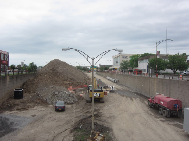
The Inner Loop of Rochester, New York, pictured in 2015. (Norman Garrick)
Realizing the devastating effect urban freeways have had on downtowns across the U.S., many cities are now contemplating some form of freeway removal. Most of these discussions haven’t gotten very far, but in Rochester, New York, officials have moved beyond the talking phase and are actually taking action.
One year ago, the city started trucking in mud from the bottom of Lake Ontario and dumping it into the ditch that was once the eastern quarter of I-490, the so-called Inner Loop, that severed downtown Rochester from its neighborhoods on all sides.
The big ‘fill’ in Rochester didn’t just happen—it came out of years of discussion and studies aimed at removing what many saw as a noose strangling downtown.

Crews filling in the removed section of the Inner Loop in 2015. (Norman Garrick)
According to Roger Brown of the Rochester Community Design Center, one of the first formal proposals for the removal of this portion of highway came in the 1990s in a report called Vision 2000, A Plan for Downtown. In 2001, the city won a small grant to study traffic on the Inner Loop. Then in 2005, Congresswoman Louise Slaughter spearheaded an effort that resulted in a $2.4 million grant that was used for preliminary engineering design for the big fill. In-between, there were design charrettes organized by the Rochester Community Design Center looking at mixed land use that could replace the footprint of the highway, as well as effective lobbying by such groups as Reconnect Rochester and Rochester City Newspaper.
This two-decade long effort culminated in the city finally winning a TIGER grant for over $17 million from the USDOT for the removal of a 2/3-mile long stretch of the Inner Loop. The total cost of the project: $22 million.
On November 14, 2014, Mayor Lovely Warren hosted Senator Charles Schumer, Representative Slaughter and other notables at a ‘First Fill’ Ceremony for removing this stretch of highway. For Rochester—and perhaps for medium-sized cities all over the country—this low-key ceremony in an often overlooked city contained the seeds of a new beginning: a new era that might also be an end to a 60-year-long planning nightmare that has bedeviled U.S. cities.
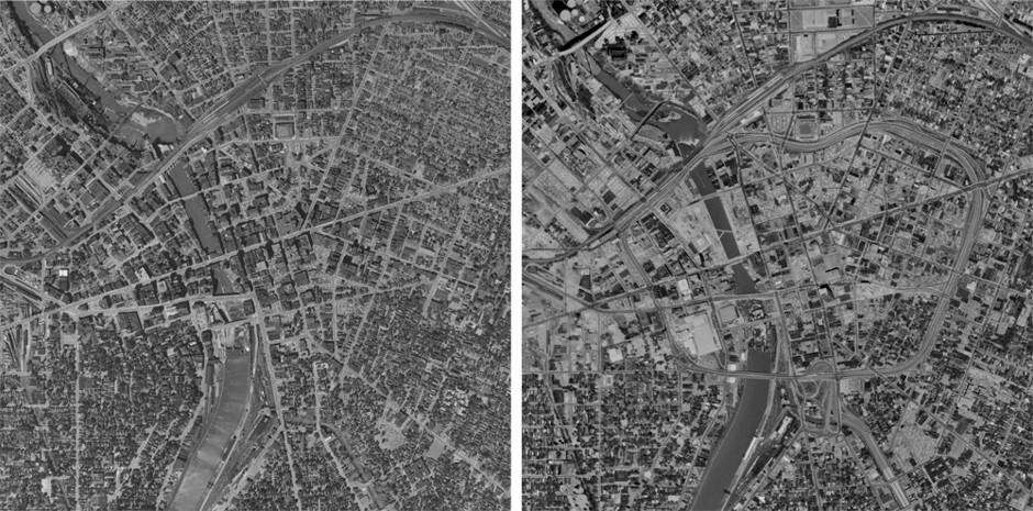
The full extent of the damage wrought by the coming of the Inner Loop can be clearly seen when comparing before and after aerial images of the city, shown below.

Aerial shots of downtown Rochester from before the Inner Loop (1951, left); and after, (1969, right.) (HistoricalAerials.com)
Without studying such before and after pictures, it is easy to forget the sheer magnitude of the devastation caused by freeways in the tightly knit urban fabric of American downtowns of the 1950s. For a freeway to be built, huge swaths of land had to be acquired and thousands of buildings had to be condemned and destroyed.
In addition, intricately connected street networks were completely disrupted and replaced by superblocks and widened city streets. Dense cities with a variety of building types saw these areas largely replaced by single-use towers surrounded by parking lots. In many American cities prior to the post-WWII wave of urban renewal, fewer than 50 percent of all commuters traveled by automobile; today that number is often above 80 percent.
But Rochester lucked out. The eastern quadrant of the Inner Loop was isolated from the main flow of traffic into the city, and thus, the traffic volume on that segment of highway was never particularly high. As a result, discussions about burying this portion of the Inner Loop weren’t sidetracked by circular debates about what to do with the traffic it would displace. It may have taken decades to move forward, but that’s still more progress than many cities can claim.
Many places grappling with the damage caused by urban freeways remain stuck in a 1950s planning paradigm, a period where planners and engineers misunderstood the relationship between the form of a city and its traffic. They thought they had to reconstruct the city to accommodate an anticipated flood of traffic in the future. What they didn’t understand was that it was the very change that they advocated that would create the vehicular traffic their models predicted.
Our research at the University of Connecticut shows that cities that transformed their downtowns with freeways, parking, and monolithic developments were flooded with traffic even while they were losing jobs and residents. The few American cities that maintained most of their prewar urban fabric saw much less growth in traffic congestion and have retained their character as vibrant walking cities.
We also know that cities that have removed freeways—usually due to an act of nature—have seen a decrease in traffic congestion. In some cases, the decrease was more than 50 percent. These examples go back at least as far as the 1970s in Manhattan and Portland, to the 1900s in San Francisco, and to the 2000s in San Francisco. Internationally, the results have been even more dramatic in the case of Seoul, South Korea.
Urban freeways did not spring up in a vacuum; they are part of a system—an approach to design and planning that is well overdue for an overhaul.
Yet most U.S. cities are still stuck in a planning paradigm that implicitly states that before we can proceed with freeway removal, we must find a plan that accommodates all the traffic currently using that facility. This is an approach that flies in the face of reason, since a freeway removal changes the context, which in turn, changes the amount of traffic. The transportation planning process that is currently used does not acknowledge this fact, even with the growing body of evidence that supports it.
This year, the USDOT has embarked on a program (in conjunction with the Congress for the New Urbanism, among others) called the Every Place Counts Design Challenge, which aims to study situations where infrastructure divides communities. This is a welcome acknowledgement at the highest level by our transportation leadership of the problems associated with urban freeways. However, this effort is likely to be hobbled by a continued adherence to a planning process that’s firmly stuck in the era that produced the problem in the first place. Urban freeways did not spring up in a vacuum; they are part of a system—an approach to design and planning that is well overdue for an overhaul.
It remains to be seen how Rochester will get the details right with this current project. Will they be able to restore the street connections between Downtown and the picturesque Park and East Avenue neighborhoods? Will they be able to resist the temptation of large-scale, homogeneous development and instead create a mixed-use fabric that restores urban vitality? Most importantly, will the early success in removing this quadrant of the Inner Loop propel Rochester into removing the rest of a highway that limits the potential of downtown and surrounding neighborhoods?
If any city is going to break the stranglehold that mid-century transportation planning still has on so many American cities, it might just be Rochester.


